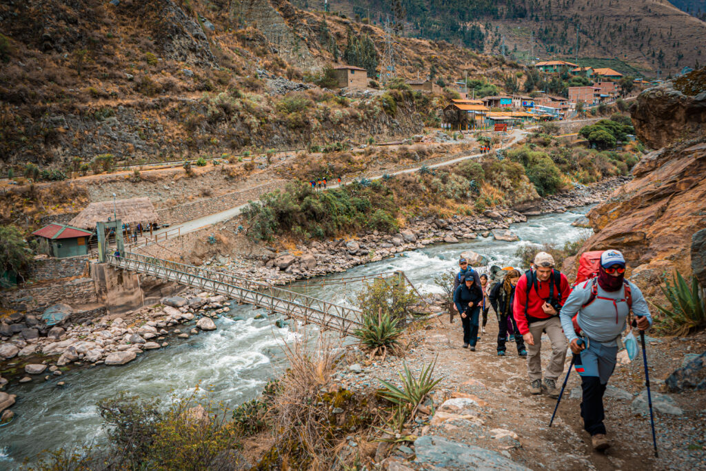
In Peru’s Andes mountains, there’s a 27-mile stone path that ends at Machu Picchu’s original entrance. The Inca Trail follows the same route used 500 years ago to reach what’s now one of South America’s most visited archaeological sites.
Unlike the train and bus that deliver 1.5 million annual visitors, the trail requires four days of walking at altitudes between 8,858 and 13,779 feet. The Peruvian government limits access to 500 people daily and requires licensed tour operators.
For trekkers willing to handle the altitude, it offers archaeological complexes with functioning water channels, stone staircases carved into cliff faces, and a final approach through the Sun Gate where sunrise still aligns with the citadel during winter solstice.
Three Ecosystems in Four Days
The trek starts at kilometer 82 of the railway to Machu Picchu. At 8,858 feet, the valley still feels warm. Day two climbs 3,937 feet to Warmiwañusca Pass at 13,779 feet. Temperature drops about 11°F for every 3,280 feet you gain. Breathing takes conscious effort.
The descent leads into cloud forest where humidity rises and trees covered in moss line the trail. This transition from temperate valley to alpine pass to subtropical forest happens over 27 miles on original Inca stonework: fitted pavers that drain water and stairs carved into bedrock.
Inca Ruins Accessible Only on Foot
The trail passes six archaeological sites built in the 1400s and early 1500s as functioning settlements in the road network.
Runkurakay at 12,335 feet served as a checkpoint. Sayacmarca sits on a rocky promontory with steep drops, reached by narrow stone stairs. Inside are residential buildings and stone fountains with water channels that still work after 500 years. Phuyupatamarca (“town above the clouds”) has six tiered ceremonial baths. Wiñay Wayna at 8,694 feet combines agricultural terraces with residential sectors.
How the Incas Built Roads on Mountain Slopes
The Qhapaq Ñan, the Inca road system, once covered over 24,850 miles. The section to Machu Picchu shows how Inca engineers worked with steep, wet mountain terrain.
The trail uses fitted stones that lock together without mortar, allowing rainwater to drain instead of pooling. On steep slopes, retaining walls prevent landslides. Drainage channels run parallel to the trail, diverting water during the rainy season.
The route incorporates ceremonial considerations. The Sun Gate faces east to catch dawn light during the winter solstice, which marked the Inca new year.
What Altitude Does to Your Body
At 13,779 feet, atmospheric pressure is about 60% of sea level. Each breath delivers less oxygen. Most people experience mild symptoms: headache, fatigue, difficulty sleeping. Most trekkers spend 2-3 days in Cusco (elevation 11,152 feet) before starting to acclimatize.
The trek requires cardiovascular endurance more than technical skill. Daily distances range from 7 to 10 miles, but altitude makes each mile harder. People with heart conditions, lung disease, or high blood pressure should consult their physician first.
How the Trek Works
Tour companies handle permit applications (submitted 6-12 months in advance) and organize the support system. Porters carry group equipment while trekkers carry daypacks (11-15 pounds). Cooks prepare meals at campsites using portable stoves adapted to high-altitude conditions.
For travelers planning this trek, working with Cusco-based operators provides advantages. Local companies work these routes year-round, developing expertise in weather patterns, altitude management, and problems specific to the Inca Trail.
Arriving Through the Sun Gate
Day four starts before dawn. The walk to Intipunku, the Sun Gate, takes about an hour through cloud forest. Intipunku sits at 8,924 feet on a ridge. Machu Picchu lies 656 feet below, surrounded by peaks. During June and July, sunrise aligns with the gate’s axis and illuminates the main structures.
What You Need Before Going
The Inca Trail requires four consecutive days of walking at altitude. Basic fitness is enough, the ability to hike 5-6 hours daily carrying a light pack, but preparation helps. Eight to twelve weeks of regular hiking with some elevation gain builds the cardiovascular base your body needs.
The dry season (May through October) offers stable weather but colder nights at high camps, with temperatures dropping to 23°F. The wet season (November through March) brings afternoon rain and greener landscapes. Permits sell out 6-12 months ahead for peak months.
The Inca Trail sits in a moderate risk range; most issues come from altitude, weather, and accumulated fatigue in people who are not prepared. With time to acclimatize, a steady pace, and guidance from trained local staff, most healthy travelers complete it safely; if you have a medical condition, this is general information and a doctor should advise you personally.
Walking with People Who Know the Mountain
Walking this route with people who know the mountain through regular use makes a practical difference. They understand how altitude affects different people, how weather shifts during the day, and what signs indicate someone needs to slow down. For many groups this role is taken by Cusco-based operators such as Inkayni Peru Tours, who work these routes year-round and adjust small details that make demanding days feel more manageable.
The trail provides access to archaeological sites that would otherwise remain unreachable, crosses ecosystems you would normally need to travel hundreds of miles to see, and demonstrates engineering solutions that have worked for 500 years. The physical challenge is real. The altitude requires respect. For people interested in Andean history and mountain landscapes, the combination makes the effort worthwhile.